BACKPACKING GRAYSON HIGHLANDS STATE PARK, VA
Known for its wild ponies and trails lined with rhododendrons, Grayson Highlands State Park in Virginia is a must for most backpackers and hikers.
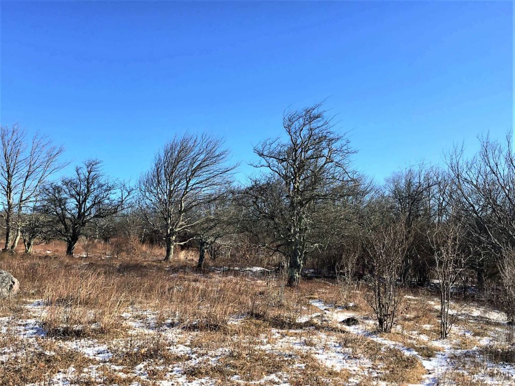
I was lucky enough to visit during the winter, which is a special time in the park. The snow on the ground paints a beautiful picture and the lack of crowds gives you a bit more breathing room.

- Research and Planning
- Arriving At Grayson Highlands State Park
- A Short Route – Perfect for Winter
- Where Can You Camp at Grayson Highlands?
- Day 1: The Journey Starts
- Day 2: Ponies and Views
- Day 3: Hiking Out – A Rugged Terrain
- Overall Impression – Grayson Highlands State Park
- A Little History
- Things to Know Before You Go to Grayson Highlands
Research and Planning
A friend also wanted to check out the park and we hastily put together a plan. It was all pretty last minute, but luckily I had some information from looking into a trip a while ago.
We’re both solid backpackers and while we packed all the right gear, the route was a bit up in the air.
Part of the difficulty we had planning was finding all of the trail information in one place.
Grayson Highlands abuts Mount Rogers Recreational Area, and all backpacking routes weave through both.
Since overnight primitive camping isn’t allowed in the park itself, you have to cross the boundary to pitch your tent.
While we could find large maps with both areas, it was difficult to get detailed information without putting it together ourselves. This meant a lot of back and forth between websites and maps. Your best bet is to use a GPS app such as AllTrails, Gaia, or The Hiking Project. They all offer good maps of the area.
The park has an overnight backpacker lot where you pay to park. This is done via an online reservation system.
If you run into difficulty with planning a solid route, I urge you to still head out. Both Grayson Highlands and Mount Rogers are easy to navigate. It’s almost impossible to become lost.
Regardless of how you tie the trails together, it’s a large circle.
Arriving At Grayson Highlands State Park
We visited the week of Thanksgiving. Since winter is a slow time, Visitor Center hours were limited and there was no staff that we saw.
Even though the Visitor Center itself was closed, there were maps in the main entranceway and the restrooms were open.

Finding the Backpacker overnight parking lot was easy since the entire park has good signage throughout.
As we were getting ready, another backpacker shared that the winds were bad. We decided to reverse the route and go counterclockwise, keeping the wind at our backs.
This wound up being the best decision we could have made and probably saved the trip.
A Short Route – Perfect for Winter
We meant to do a longer route but got a bit off-track when we changed direction. Overall, due to the high winds and cold weather, it was probably smart that we shortened it a bit.
Starting at the Backpackers lot, we headed up the spur trail to pick up the northbound Appalachian Trail. Then spent the night at Wise Shelter.
Continuing on the northbound Appalachian Trail, we connected with the Crest Trail, then switched to the Pine Mountain Trail which parallels Crest.
Just past Rhododendron Gap, which is where Wilburn Ridge Trail intersects with Pine Mountain, we kept straight and got on the southbound Appalachian Trail (it makes sense when you see a map).
Dropping off gear at Thomas Knob shelter, we did a day hike to the top of Mount Rogers, then spent the night at the shelter.
On our last day, we backtracked down the Appalachian Trail and then made the right on Wilburn Ridge Trail which took us back to the parking lot.
I love Grayson Highlands in winter. It’s a great one of the best places to go backpacking in the southeast.
Where Can You Camp at Grayson Highlands?
Backcountry camping is not allowed in Grayson Highlands State Park, except for at Wise Shelter. You must sleep in the shelter if you camp here, there is no backcountry tent camping allowed anywhere in the park.
However, you can camp overnight in Mount Rogers Recreational Area and Jefferson Wilderness which both abut the park. This is why it’s important to know the boundaries.
When it comes to the Wise Shelter, if you’d like to stay in a tent, just continue on the Appalachian Trail northbound for 50 yards to a gate. This is the entrance to Mount Rogers Recreational Area. There are great tent spots, easy access to water, and a bear locker in the Mount Rogers Area.
As a matter of fact, you’ll find good tent spots just outside almost every gate separating the park from the Wilderness Areas.
Day 1: The Journey Starts
Heading from the Parking Lot to Wise Shelter
The journey started by taking the spur trail from the parking lot to the northbound Appalachian Trail.
Heading out, there was snow on the ground, which is pretty exciting to those of us that don’t live in the mountains. Thanks to our decision to reverse the route, the wind remained at our backs the entire time.

We arrived at our first camp early, but due to the winds and the distance to the next camp, we opted to stay in the area.
It was cold and a little boring, but at least the shelter offered protection from the wind.
So what do bored backpackers do to pass the time? Well, after inspecting the bear locker, hiking around the area, checking out the two privies (Yep, two. I love you Virginia), and taking some photos, it was 4:30 pm and seemed like a reasonable time to eat.
After dinner and storing the food, we hunkered down. As the evening progressed, the winds started to pick up from the west.
I had been expecting the usual mountains with steep climbs and some means of natural shelter against the winds.
What I didn’t realize is that Grayson Highlands Park is pretty much at the top of the mountain. You’re walking along the top and upper ridge so it’s relatively flat with little shelter.
Another exciting thing about Grayson Highlands is the wild ponies which we hadn’t seen yet. In the morning, I noticed a hoof print in the snow nearby so I’m pretty sure one of them paid us a visit.
Day 2: Ponies and Views
Continuing on the Appalachian Trail
It was a whole lot brighter and warmer with the sun shining and the winds dying down on day two. I could feel my toes so life was looking up.
One of the best parts of the trip was that we pretty much had the park to ourselves. The only people we ran into were a couple of South Bound Appalachian Trail thru-hikers and two local hunters heading back to their camper.
It was relaxing not having to fight for space or continually pass people or move over. I had time to look around and really observe the area.
Looking at the bare trees, you could tell heavy winds come from the west frequently. The branches grow towards the east, looking like the wind is blowing even when it’s not.
It’s a little weird.
We got off the Appalachian Trail to pick up the Crest Trail, an old roadbed with good views.
Realizing the Pine Mountain Trail, which is more of a hiking foot trail, was literally twenty feet away, we moved over.
The two trails pretty much ran in parallel so it was mainly a difference in scenery.
Seeing the Wild Ponies
I had been a little disappointed we hadn’t run into the wild ponies yet. The local hunters assured us they were further up the trail and given our route, we would definitely pass them.
As we rounded the trail just before Rhododendron Gap, three of them were grazing. They were smaller than I had imagined with thick winter coats and clearly accustomed to the cold weather.
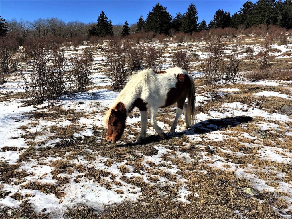
The ponies didn’t appear to pay attention to us, but I swear they were keeping an eye out.
I’m pretty sure if I had opened my pack, they would have run over for food. Familiar with humans, they tolerate photos taken from a distance.
Mount Rogers – The Highest Peak in Virginia
Continuing on Pine Mountain, just past the intersection with Wilburn Ridge Trail, we kept straight and got on the southbound Appalachian Trail, heading towards Mount Rogers.
We arrived at the Thomas Knob shelter fairly early, but not too bad.
In theory, we could have completed the loop in 1 to 2 days, but if you’re dead set on a weekend of camping, you want your weekend.
Having some time, we opted to hike to the top of Mount Rogers, against the advice of others saying it was treed in and not exciting.
They were right. The survey marker in the photo below is the only means of knowing you’re at the top of the mountain.

I can honestly say I don’t feel any bragging rights about standing at the top of the tallest mountain in Virginia.
It’s not worth it, but let’s face it – you’re going to do it anyway.
Thomas Knob Shelter
Arriving back at the shelter, it was time to explore.
Thomas Knob shelter is two levels with a fully enclosed upstairs, like an attic.
Now, this is how you live on the trail! Shelters with attics are a yes in my book.
There was a good water source less than 200 feet away and a solid bear locker in a field about 300 feet away.
Unfortunately, while we had initially escaped having the ponies follow us, another hiker opted to eat potato chips while hiking and created a pony parade.
For some reason, the ponies stopped at the shelter, even though the hiker with the potato chips kept going.
Three ponies wound up hanging out at the shelter, just staring at us. One turned sideways and tried to make like he wasn’t looking at me, but he was.
They stayed for hours. HOURS. Just standing there and staring.
Deciding now was a good time to get some water, I headed out ignoring the creepy ponies.
A Spectacular Sunset
Sunset over the mountains behind the shelter was absolutely amazing. My camera didn’t really capture the colors well.
Even though the photos have some yellow, the sky was actually completely orange. It lasted for a long time and was a great ending to the day.

Day 3: Hiking Out – A Rugged Terrain
A Spectacular Sunrise
In the morning, I headed out to get our food and stopped in my tracks. The view was amazing. Sunrise looked a lot like the previous night’s sunset.
Starting out as an orange glow, it faded to a bit of pink, then a light yellow before dawn broke.

Even now, I look at my pictures and, if they weren’t time-stamped, I would be hard-pressed to pick out sunset from sunrise.
Grayson Highlands State Park is definitely a special place.
Hiking through Rugged Terrain
We headed out by backtracking the Appalachian Trail (now northbound) and picking up the Wilburn Ridge Trail.
Once we turned on Wilburn Ridge, everything changed.
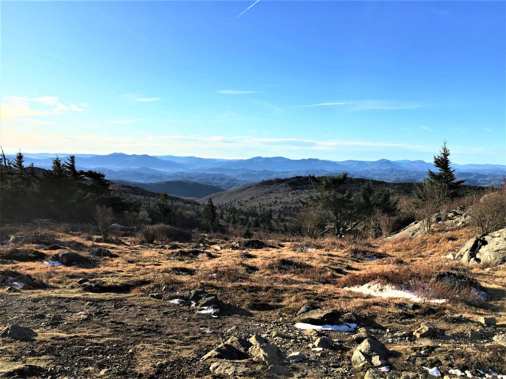
Scrambling over rocks, we emerged in a large open, barren space. I felt like a new settler exploring rugged terrain, years ago.
The landscape was exciting and yet felt foreign. It was nothing like the snow and grassy meadows we had seen the previous days.
It was truly breathtaking with amazing views.
I now have a really good feel for the area and will definitely be coming back to explore it further.
Overall Impression – Grayson Highlands State Park
Originally, I pictured something similar to the Appalachian Mountains in North Carolina and Tennessee, like Carvers Gap to 19E with steep climbs, wooded trails, and some balds.
The first surprise was the diverse landscapes throughout the park. We passed open meadows, thickly forested areas, and stark, rugged terrain.
I was also not expecting a flat area with few climbs.
Most of the elevation gain is in your car driving up the mountain to the parking lot. After that, you’re hiking in a valley or bald around the top.
Imagine a wide bald area, miles in radius, at the top of a mountain. Other mountains are nearby with trees, yet the one you’re standing on appears bald.
This unique landscape offers high elevations with nothing in the way of your spectacular views.
Everywhere we turned, there was a photo opportunity.

The open fields, the trees leaning to the east from years of westward winds hitting them, the ponies out in the fields, the mountain views off in the distance, Grayson Highlands is a special place. I get it now.
A Little History
Grayson Highlands State Park was established in 1965 as Mount Rogers State Park. This playground is now approximately 4500 acres.
The park is adjacent to the Mount Rogers National Recreation Area, part of Jefferson National Forest.
Fun fact: Several areas of the park are actually named after early settlers.
Massie Gap is named for Lee Massey who lived in the area in the late 1800s and early 1900s. Wilburn Ridge is named after Wilburn Waters, a famous bear hunter, and wolf trapper.
Besides hikers, the park attracts fishermen and has also garnered fame amongst bouldering enthusiasts.
The ponies have existed in the mountains since the 1940s which is prior to the National Forest taking over the area. The Wilburn Ridge Pony Associate was formed in 1974 to take ownership of the ponies and help manage them.
Things to Know Before You Go to Grayson Highlands
If you’re backpacking, you do have to pay for overnight parking in the backpacking lot. You can do this online through ReserveAmerica.

The area has had bear issues for the past few years. The main cause was improper food storage which led to the installation of bear lockers.
This is not the area to push your luck. Store your food and anything with a scent in the lockers. If not for you, then for the next campers coming through.
The issue appears to be getting better, but only through continued diligence will this area remain safe.
Most trails are not blazed, but they are easy to follow and there are plenty of maps online and via multiple apps.
We didn’t have any issues with the ponies but a few locals told us some of them are prone to kicking and biting. Heed the warnings and don’t feed or try to pet them.
If you do go in the summer, bring sunscreen. You’ll find yourself exposed to the sun for long periods of time. Bug spray is also probably a good idea.
The park can become crowded in spring and summer. If you’re an experienced backpacking or hiker, it’s doable in winter. Just make sure you have the right gear.

